Back Glacera Viedma Catalan Ventisquero Viedma CEB Viedma-Gletscher German Glaciar Viedma Spanish یخچال ویدما Persian Glacier Viedma French קרחון ויידמה HE Ghiacciaio Viedma Italian Vjedmos ledynas Lithuanian Ventisquero Viedma Swedish
| Viedma Glacier | |
|---|---|
 | |
| Type | Valley glacier |
| Location | Santa Cruz Province, Argentina Magallanes y la Antártica Chilena, Chile |
| Coordinates | 49°27′36″S 73°11′42″W / 49.46°S 73.195°W |
| Terminus | Lake Viedma |
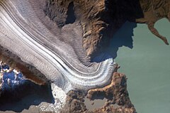
Viedma Glacier is a large glacier that is part of the huge Southern Patagonian Ice Field, located at the southern end of mainland South America. Viedma Glacier is a valley glacier and its moraine-rich terminus flows into the western end of Lake Viedma, which is fed primarily by its melting ice. Viedma Glacier is located in the undefined part of the limit between Chile and Argentina, in Argentinian legislature it is in Los Glaciares National Park[2] which was declared a World Heritage Site in 1981.[3][4] in Chilean legislature part of it is in Bernardo O'Higgins National Park. The Southern Patagonian Ice Field is 13,000 square kilometres (5,000 sq mi); Viedma Glacier is one of the Ice Field's 48 outlet glaciers that have more than 20 square kilometres (7.7 sq mi) of ice field area each.[5]
- ^ "Viedma Glacier and Mt. Fitzroy, Argentina : Image of the Day". earthobservatory.nasa.gov. Retrieved 2009-10-12.
- ^ "Viedma Glacier, Argentina : Image of the Day". earthobservatory.nasa.gov. Retrieved 2009-10-12.
- ^ "Welcome to Los Glaciares National Park". www.losglaciares.com. Retrieved 2009-10-13.
- ^ "Los Glaciares - UNESCO World Heritage Centre". whc.unesco.org. Retrieved 2009-10-13.
- ^ Lliboutry, Louis. "USGS P 1386-I -- Chile and Argentina - Wet Andes". pubs.usgs.gov. Retrieved 2009-10-12.
